
- This event has passed.
Three Decades Working with Islamic Maps: An Overview
April 3, 2023 @ 12:00 pm - 2:00 pm
FreeThree Decades Working with Islamic Maps: An Overview
Karen Pinto, Associate Scholar, Religious Studies, University of Colorado-Boulder
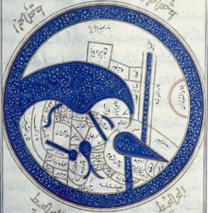
How did cartographers imagine the “Muslim” world? What is Islamic about Islamic cartography? Why did the cartographers not strive for mimesis and employ a visual language of stylized forms?
What are the Late Antique, Ancient, and Prehistoric roots of Islamic cartography? How does it connect to other cartographical imaginations of the time—Christian, Chinese, Indic and otherwise?
Was there a conception of dār al-Islam vs. a dār al-ḥarb in “Muslim Cartography? Who was considered us and who was the other in this cartographical rendition of the world?
How can absences, presences, and anomalies be investigated to reveal unknown historiographical nuggets?
Register via Zoom
Karen Pinto specializes in the history of Islamic cartography and its intersections between Ottoman, European, and other world cartographic traditions. Born and raised in Karachi, Pakistan, educated at Dartmouth and Columbia, Karen Pinto is into pre-modern maps of all kinds and sizes. She specializes in medieval Islamic maps and has spent the better part of three decades hunting them down in Arabic, Persian, and Turkish manuscripts around the world. She has a 3000-strong image repository of Islamic maps—many that have never been published before. Her book, Medieval Islamic Maps: An Exploration (Chicago 2016), won a Choice’s 2017 Outstanding Academic Title award. Karen is also working on monographs on the Mediterranean, al-Andalus and the Maghrib in the Islamicate Cartographic Imagination along with a smaller book on the puzzling topic of “What is ‘Islamic’ about Islamicate Maps?” In addition, Karen has published articles on medieval Islamic maps of the Maghrib and Mediterranean (“Passion and Conflict: medieval Islamic views of the West” and “Surat Bahr al-Rum: Possible Meanings Underlying the Forms”) and she has examined Islamic cartographic connections with Ottoman Cartography (“Searchin’ his eyes, lookin’ for traces: Piri Reis’ World Map of 1513 & Its Islamic Iconographic Connections” and “The Maps Are The Message: Mehmet II’s Patronage of an ‘Ottoman Cluster’”). Of late, she is seeking to identify Islamo-Christian cartographic connections including the possibility that the Emperor Frederick II owned and consulted a copy of al-Iṣṭakhrī’s Kitāb al-masālik wa-al-mamālik (Book of Routes and Realms) and that the famous eleventh century Andalusi prince and scholar al-Bakrī may have relied on a copy of Isidore’s Etymologiae for parts of his geography.
Copies of her published work can be accessed through: https://colorado.academia.edu/KarenPinto